The tremendous number of green spaces, parks, and patches of forest that may be enjoyed on the island of Singapore is one of the most astonishing elements of a city-state that is as comparatively tiny as Singapore.
This is because Singapore is an island. The Southern Ridges is easily one of the simplest, tastiest, and most fun excursions that can be undertaken in Singapore.
It also happens to be one of the most well-known. In the following paragraphs, we are going to discuss those things.

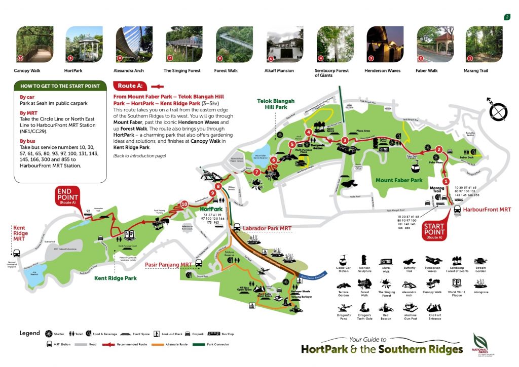
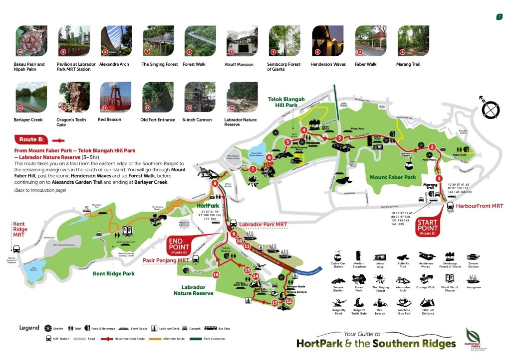
The Southern Ridges are really ten kilometres of trails that run more or less in a straight line and connect the numerous parks and reserves that are located in the southern section of Singapore.
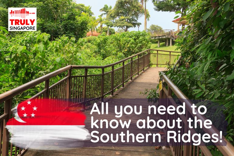
The hike gets its name from the numerous minor ridges that are traversed by the paths as they wrap around the tops of the ridges. In many instances, a walkway system that has been intelligently developed makes it possible to stroll above the forest.
This reduces the negative influence that tourists have on the ecosystem while also enabling people to contemplate nature from an uncommon and intriguing vantage point.
Labrador Nature Reserve, Kent Ridge, Hort, Telok Blangah Hill, and Mount Faber parks may all be reached along a continuous path that runs along the Southern Ridges.
Our planned stroll starts about in the middle of the path and passes through the Telok Blangah Hill and Mount Faber parks. If you started in the middle of the path and walked to the right, it would correspond to the right half of the route on the picture map.

The best time to hike the Southern Ranges is in the early morning or evening, when it's not so hot here.
The magnificent Alexandra Arch bridge may be seen at the trail’s commencement (location on the map). The best method to get to the beginning of the walk is to take any of the following bus lines: 51, 61, 93, 97, 100, 120, 166, or 963.
There is a bus stop right next to the bridge for these lines. Your location in Singapore will determine which bus route you take if any, as there are several options.
The Floral Walk at HortPark is connected to the Forest Walk by way of the Alexandra Arch, which is a pedestrian bridge that is 80 metres in length. The LED lights are used to illuminate it throughout the night, and the resulting display is one of a kind.
When you reach Alexandra Park, proceed to the entrance and turn left onto the route that heads east. If you stand with your back to the sea (which you will be able to make out in the distance), you will need to go to the left in order to get your bearings.

Following that, you will go onto the paths that make up the Forest Trek, which is a walk through the forest and is located within Telok Blangah Hill Park. This particular section of the park is traversed by more than a kilometre of elevated walkways that gradually wind their way upward. There are signs all along the trail that provide information on the birds and plants that may be observed while taking the stroll.
The area of Forest Park that is referred to as the Singing Forest (singing forest) got its name because it is home to more than 200 different kinds of trees that are frequented by songbirds. If you are fortunate, you will be able to hear the enchanting songs of some of them.
The final part of the park’s pathways makes a steep elevation to the highest point, where the Forest of Giants may be found. This area is home to several huge tree species that are on the verge of extinction. Carry on walking in the direction indicated by the signs pointing in the direction of the Henderson Waves.
You’ll find the only drink vending machines along a significant portion of the trail in a tiny square that opens up into the forest. This area is located at the beginning of the path (it is identified on the map of the walk that you will see at the end of this text). If you did not have a drink with you, this would be a good moment to take advantage of the chance to hydrate yourself.
Soon, you will arrive at the remarkable bridge known as the Henderson Waves, which is 36 metres tall and links the Telok Blangah Hill and Mount Faber parks in Singapore (it is the highest pedestrian bridge in Singapore).
The structures that make up the bridge are undulating, much like the waves that may be found in the ocean. In addition to being highly popular, it is a great area to take a seat and relax.
The final segment of the path goes to Mount Faber, which is the location of the top station of the Singapore Cable Car. This station connects the summit of the hill with Sentosa Island (more details on their website).

If you don’t feel like finishing the trek and instead want to take the cable car to Sentosa Island so you can spend the afternoon there instead, this is the best place to get on the cable car so you can make the crossing. The Bell of Happiness is a popular tourist attraction that is right next to the cable car station.
The next portion of the hike takes place in the woods, on a steep trail that, happily, is completely downhill. The route can be taken via wooden steps or a dirt road. At the conclusion of the route, you will find yourself standing in front of the expansive Vivo City shopping area.
You have the choice to either get a bite to eat at the shopping centre (which features an infinite number of restaurants) or hop on the train and travel to a different neighbourhood in the city.
Southern Ridges Trail Map/Route
Route A

Route B

How to get to Southern Ridges?
By car
Park at Seah Im public carpark
By MRT
Take the Circle Line or North East
Line to HarbourFront MRT Station
(NE1/CC29).
By bus
Take bus service numbers 10, 30,
57, 61, 65, 80, 93, 97, 100, 131, 143,
145, 166, 300 and 855 to
HarbourFront MRT Station
Southern Ridges Address
Henderson Road, Southern Ridges, Singapore
Practical suggestions
Take a look at this list of suggestions if going on a walk is something you are considering doing.
- Bring rain gear with you because there aren’t many places to take cover along the trail.
- Bring water, and bring enough of it. Along the route, there are just a few locations where you can get refreshments, and both the temperature and the amount of humidity are rather high.
- The trail may be hiked in the other direction from that which is mentioned above. However, you should be aware that if you choose to go in this manner, you will have to contend with a very steep ascent right at the beginning of the walk.
- You are not required to wear any particular type of footwear, although it is recommended that you wear something that is water-resistant.
- You are free to go for a stroll either in the morning or in the afternoon. However, due to the scorching heat that is always present in Singapore, we suggest doing it in the morning, setting off at an early hour, and arriving at the conclusion of the trip during the hottest part of the day.
- The trip will take between two and three hours of your time, give or take an hour and a half, depending on how often you want to stop and get further information about the many locations you are going to be seeing.
- You could run into some monkeys on the path. Exercise extreme caution. It is against the law to give them food, but if they think you have anything to eat on you, they will try to get it from you nonetheless.
Reference:
- https://www.nparks.gov.sg/~/media/nparks-real-content/gardens-parks-and-nature/diy-walk/diy-walk-pdf-files/hortpark-and-southern-ridges.pdf
- https://en.wikipedia.org/wiki/Southern_Ridges
Frequently Asked Questions
What is Southern ridge’s distance?
10 kms (6.2 miles)
Southern Ridges Loop cycling
Cycle through green, open spaces across Mount Faber Park and Telok Blangah Hill Park on The Southern Ridges Loop. The route consists of short but steep hill terrain, so switch to your lowest gear while moving uphill.
Is southern ridges open?
Southern Ridges is Open 24×7
Southern ridge forest Entrance fees?
It’s Free!
Also Read:


